

Harmonised Radar Altimeter Data | ADS
Satellite-based radar altimeters actively measure the water level of the ocean and inland waters along their ground tracks. In addition, they record the wind and significant wave heights. Nineteen radar altimeter missions have been launched into orbit since the mid-1980s. Most of these missions use different data formats and are available with different processing standards.
In order to generate long and consistent time series of water levels, the Altimeter Database and Processing System (ADS)was developed at the GFZ, which combines all missions and enables uniform processing. In addition, the stability and consistency of the individual missions is regularly checked. Apart from the actual altimeter data, ADS also contains current correction models for the sensors, the satellite orbits and the environmental influences on the measurements. For example, the influence of orbit modelling on the water level measurements can be quantified and external models can also be validated. With the help of the ADS, data processing can be optimized for the respective region and scientific question.
ADS currently includes data from the following completed missions:
Geos-3 (1975-1978), Geosat (1985-1989), ERS-1 (1991-1996), Topex/Poseidon (1992-2005), ERS-2 (1995-2011), GFO-1 (2000-2008), Jason-1 (2002-2013), Envisat (2002-2012), ICESat (2003-2009), Jason-2 (2008-2019), and HY-2A (2011-2020),
and the following still active missions:
Cyrosat-2 (2010), Saral (2013), Jason-3 (2016), Sentinel-3A/B (2016/2018), HY-2B (2018), HY-2C (2020), Sentinel-6MF (2020), HY-2D (2021), and SWOT (2022).
Altimetry over the Ocean
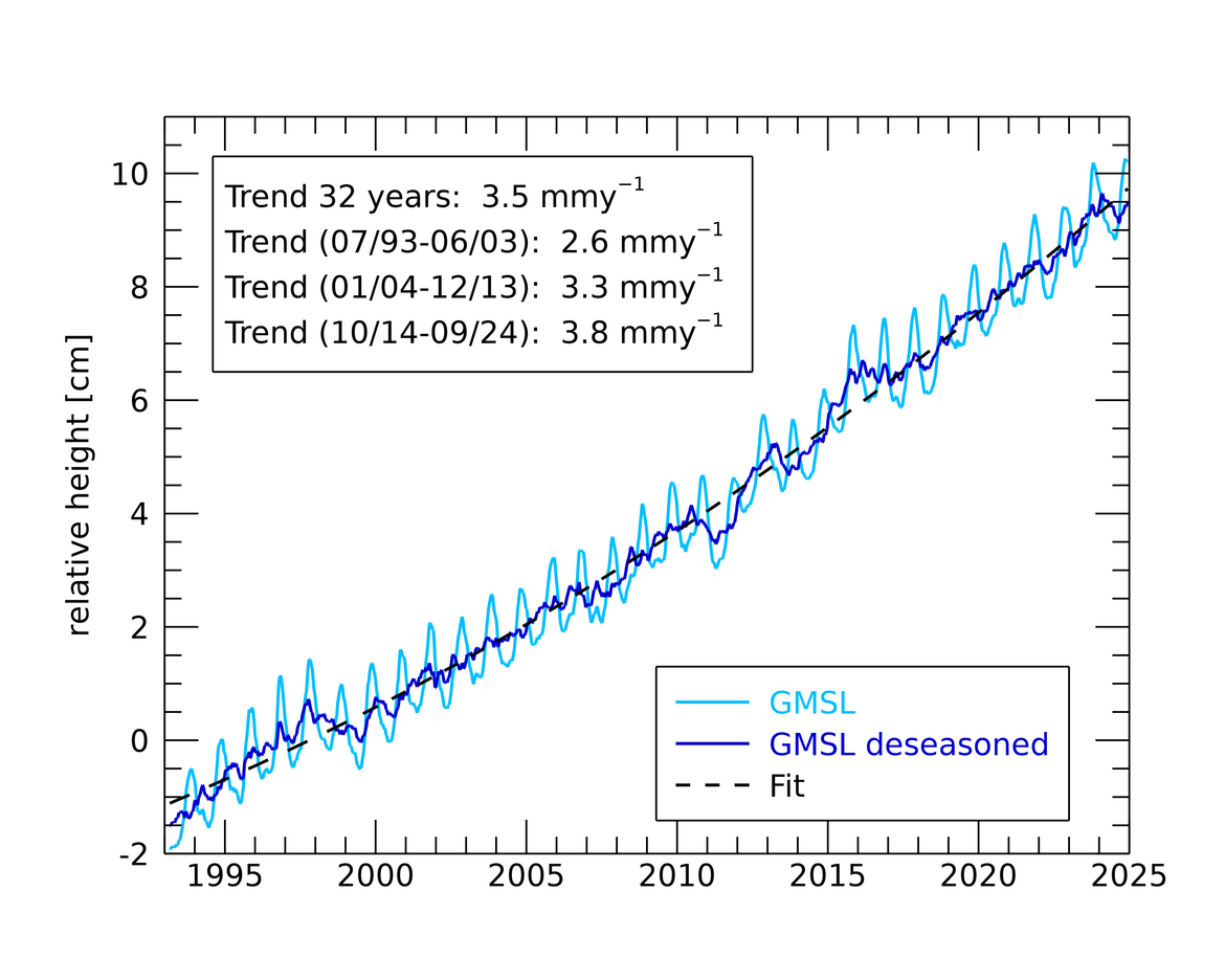
Classic application examples for the harmonized data are the observation of the global mean sea level and the regional distribution of the rise. The radar altimeter measurements show a global rise of approx. 11 cm since 1993. The average rise is 3.5 ± 0.3 mmy-1, with a clear acceleration being observed. As a result of the superposition of various processes in the solid earth, in the ocean and in the atmosphere, the sea level rise is not evenly distributed across the oceans.
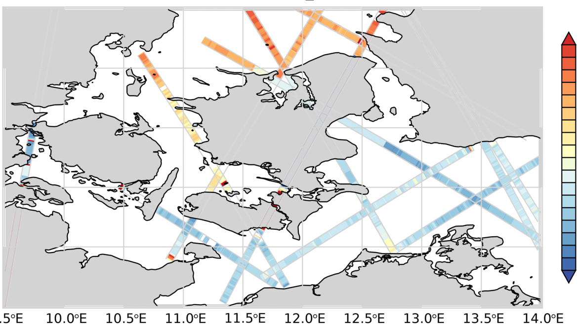
The sensors, the correction models and the analysis strategies are continually being further developed, whereby the accuracy increases and processes in direct coastal proximity and in inland waters can be examined to an increasing extent. On the basis of the high-rate data, which are also contained in ADS, water levels on the North Sea coast and exchange processes between the North Sea and the Baltic Sea are examined, for example.
Altimetry over Inland Waters
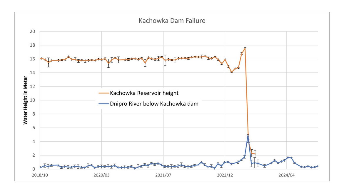
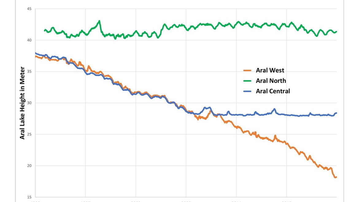
Another possible application of harmonized radar altimetry is the investigation of inland waters. Our methods can be used to observe and analyze the filling levels of dams, changes in lake levels and the rise and fall of rivers. The time series, which date back to 1993, enable us to observe and analyze changes in the continental water cycle. We are also working on methods that allow us to forecast water availability for short-term periods. This work contributes to important projects such as CAWa and GreenCentralAsia. The time series are made freely accessible via the SDSS for use by the general public and political decision-makers.
Project partners:
- AWI, CAIAG, Hereon, Geomar
- CLS, DTU, TUD, University of Bonn and TUM
- Second Institute of Oceanography, State Oceanic Administration (SOA), Chinese Academy of Surveying and Mapping
- MARUM - Zentrum für Marine Umweltwissenschaften, Universität Bremen, ZMT- Leibniz-Zentrum für Marine Tropenforschung
Project duration:
- since 2000
Budget:
- Strategie Fonds Helmholtz Gemeinschaft: 2000-2003 (SEAL)
- BMBF, Geotechnologien: 2005-2008 (SEAVAR)
- ESA: 2009-2010 (REAPER)
- ESA: 2010-2013 (ESA-CCI sea level)
- DFG, SPP 1889 SeaLevel: 2016-2023 (CoRSEA)
- BMBF, FONA3: 2017-2020 (SEAHAP)
POF IV: 2021-2027
Project-related publications:
- Schöne, T., Illigner, J., Zubovich, A., Zech, C., Stolarczuk, N., Sharshebaev, A., Borisov, M. (2024 online): Performance Analyses of Sentinel-3A and Sentinel-3B Over Lake Issyk Kul (Kyrgyzstan). - In: International Association of Geodesy Symposia, Berlin, Heidelberg: Springer. https://doi.org/10.1007/1345_2024_268
- Esselborn, S., Schöne, T., Illigner, J., Weiß, R., Artz, T., Huang, X. (2022): Validation of Recent Altimeter Missions at Non-Dedicated Tide Gauge Stations in the Southeastern North Sea. - Remote Sensing, 14, 1, 236. https://doi.org/10.3390/rs14010236
- Abdalla, S., et al. (2021): Altimetry for the future: Building on 25 years of progress. - Advances in Space Research, 68, 2, 319-363. https://doi.org/10.1016/j.asr.2021.01.022
- König, R., Reinhold, A., Dobslaw, H., Esselborn, S., Neumayer, K., Dill, R., Michalak, A. (2021): On the effect of non-tidal atmospheric and oceanic loading on the orbits of the altimetry satellites ENVISAT, Jason-1 and Jason-2. - Advances in Space Research, 68, 2, 1048-1058. https://doi.org/10.1016/j.asr.2020.05.047
- Artz, T., Weiss, R., Esselborn, S., Illigner, J., Schöne, T. (2020): Lokal optimierte Nutzung der Satellitenaltimetrie zur Erfassung des Meeresspiegels. - Hydrographische Nachrichten, 116, 77. https://doi.org/10.23784/HN116-12
- Rudenko, S., Esselborn, S., Schöne, T., Dettmering, D. (2019): Assessment of ITRF2014 for precise orbit determination of altimetry satellites. - Solid Earth, 10, 1, 293-305. https://doi.org/10.5194/se-10-293-2019
- Schöne, T., Zubovich, A., Zech, C., Illigner, J., Sharshedaev, A., Mandychev, D., Shakirov, A., Stolarczuk, N., Haghshenas Haghighi, M., Gerlitz, L., Gafurov, A., Moldobekov, B., Lauterjung, J. (2019): In Situ and Remote Water Monitoring in Central Asia — The Central Asian Water (CAWa) Network. - In: Müller, L., Eulenstein, F. (Eds.), Current Trends in Landscape Research, (Innovations in Landscape Research), Cham: Springer, 599-610. https://doi.org/10.1007/978-3-030-30069-2_27
- Bott, L.-M., Illigner, J., Marfai, M., Schöne, T., Braun, B. (2018): Meeresspiegelanstieg und Überschwemmungen an der Nordküste Zentraljavas: Physische Ursachen und soziale Anpassungsmaßnahmen = Sea level rise and flooding on the north coast of central Java. Physical causes and social adaptation. - Geographische Rundschau, 70, 4, 4-8.
- Esselborn, S., Rudenko, S., Schöne, T. (2018): Orbit-related sea level errors for TOPEX altimetry at seasonal to decadal timescales. - Ocean Science, 14, 205-223. https://doi.org/10.5194/os-14-205-2018
- Schöne, T., Shum, C., Tamisiea, M., & Woodworth, P. (2017). GGOS Focus Area 3: Understanding and Forecasting Sea-Level Rise and Variability. gfzpublic.gfz-potsdam.de/pubman/item/item_2650896_2
- Dobslaw, H., Bergmann-Wolf, I., Dill, R., Poropat, L., Thomas, M., Dahle, C., Esselborn, S., König, R., Flechtner, F. (2017): A new high-resolution model of non-tidal atmosphere and ocean mass variability for de-aliasing of satellite gravity observations: AOD1B RL06. - Geophysical Journal International, 211, 1, 263-269. https://doi.org/10.1093/gji/ggx302
- Rudenko, S., Dettmering, D., Esselborn, S., Fagiolini, E., Schöne, T. (2016): Impact of Atmospheric and Oceanic De-aliasing Level-1B (AOD1B) products on precise orbits of altimetry satellites and altimetry results. - Geophysical Journal International, 204, 3, 1695-1702. https://doi.org/10.1093/gji/ggv545
- Esselborn, S., Schöne, T., Rudenko, S. (2016): Impact of time variable gravity on annual sea level variability from altimetry. - In: Rizos, C., Willis, P. (Eds.), IAG 150 Years: Proceedings of the IAG Scientific Assembly in Postdam, Germany, 2013, (International Association of Geodesy Symposia; 143), Cham: Springer International Publishing, 55-62. https://doi.org/10.1007/1345_2015_103
- Esselborn, S. (2013): Meeresspiegeländerungen und Küstenschutz, REKLIM Newsletter, 6-7.
- Schöne, T., Esselborn, S., Rudenko, S., Raimondo, J.-C. (2010): Radar Altimetry Derived Sea Level Anomalies - The Benefit of New Orbits and Harmonization. - In: Flechtner, F., Gruber, T., Güntner, A., Mandea, M., Rothacher, M., Schöne, T., Wickert, J. (Eds.), System Earth via Geodetic-Geophysical Space Techniques, Springer, 317-324. https://doi.org/10.1007/978-3-642-10228-8_25

