

Coastal sea level dynamics monitored by satellite altimetry and tide gauges | COLSATI
Satellite-based radar altimetry is a technology that has been tried and tested for more than 30 years and provides snapshots of the water level at intervals of ten to thirty days. The signal is often disturbed in the last 20 km off the coast, but this distance can now be reduced to 2 to 5 km thanks to improved sensors and adapted data evaluation. In order to generate long and consistent time series of the water level, the stability of the measurements must be continuously checked and possible offsets between successive missions must be determined.
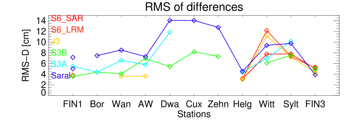
In the COLSATI project, as members of the Ocean Surface Topography Science Team, we use tide gauge data from the German North Sea coast, which is referenced with a Global Navigation Satellite System (GNSS), to determine the accuracy and stability of current radar missions. The processing of the high-rate satellite data is adapted to the coastal conditions. The study of eight missions from 2002 to 2024 shows that the accuracy is between 1.5 cm and 3.7 cm, depending on the mission. The regional offset between the missions can be determined with an accuracy of approx. 2 cm by comparing to the tide gauges. Improvements can be expected here through new models of the mean sea surface height. The sea level rise since 1993 along the German North Sea coast is 2.5 to 3.4 mm/year, whereby the estimation error is currently up to ±1 mm/year due to the superimposed ocean dynamics.
The following priorities are planned for the further course of the project:
- Consolidation of the estimate of sea level rise along the German coasts, in particular by linking it with high-resolution ocean simulations
- Validation of the Sentinel-3C and Sentinel-6B missions planned for launch in 2025
- Better understanding of the dynamics of coastal sea level on spatial scales of around 10 km with a focus on the vicinity of the tide gauge stationsAnalysis of storm surges based on high-rate altimeter measurements and snapshots from the SWOT mission
Project partner:
- Bundesanstalt für Gewässerkunde (BfG)
- Bundesanstalt für Seeschifffahrt und Hydrographie (BSH)
Project duration:
- seit 2019
Budget:
- BfG: 2019-2021
- Household POF IV: 2021-2027
Projekt related publications:
- Esselborn, S., Schöne, T.: Validation of multi-mission radar altimetry since 2016 at coastal tide gauges, 30 Years of Progress in Radar Altimetry Symposium, Montpellier, France, 2-7 September 2024.
- Esselborn, S., Schöne, T., Illigner, J., Weiß, R., Artz, T., Huang, X. (2022): Validation of Recent Altimeter Missions at Non-Dedicated Tide Gauge Stations in the Southeastern North Sea. - Remote Sensing, 14, 1, 236. https://doi.org/10.3390/rs14010236
- Artz, T., Weiss, R., Esselborn, S., Illigner, J., Schöne, T. (2020): Lokal optimierte Nutzung der Satellitenaltimetrie zur Erfassung des Meeresspiegels. - Hydrographische Nachrichten, 116, 77. https://doi.org/10.23784/HN116-12
- Schöne, T., Shum, C., Tamisiea, M., & Woodworth, P. (2017). GGOS Focus Area 3: Understanding and Forecasting Sea-Level Rise and Variability. https://gfzpublic.gfz-potsdam.de/pubman/item/item_2650896_2
