

Sea Level Change and its Hazardous Potential in the South China Sea and Adjacent Waters | SEAHAP
Sea level fluctuations are a natural occurrence on various time scales in the history of the Earth, occurring in connection with warm and cold phases of our planet. In addition to this natural variability, the question of man-made changes in the climate is in the public focus. Sea level rise (SLR) is a well-known consequence of man-made global warming, impacting society and the economy. A critical factor that is rapidly increasing awareness is the additional threat to heavily populated coastal cities due to the superposition of regional and local subsidence with the SLR. China is no exception. Today, around 200 million people live in the coastal region or on islands, and more than two million square kilometers of the country are less than one meter above the current sea level. Many of the largest cities (Shanghai, Hong Kong, Guangzhou, Macao, etc.) are located in these coastal regions, making them vulnerable to SLR. Other countries bordering the South China Sea are also affected by sea level rise. Manila is a prominent hotspot region. Regions with ongoing subsidence, such as Shanghai, Manila, and Jakarta, are particularly vulnerable due to their location in river basins (alluvial plains). It is imperative for coastal planning, land use, and economic development to understand sea level changes and projections for coastal regions.
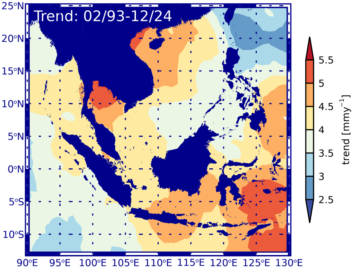
Radar altimetry (RA) has played an increasingly important role in monitoring global sea level. Since the mid-1980s, various missions have provided a wealth of data on the state and change of sea level. However, to ensure the accuracy of regional trends derived from altimeter measurements, it is essential to employ consistent correction algorithms across missions. To standardize the derived sea level models, it is essential to review them, standardize them, and investigate regional approaches. The derivation of long-term trends is further complicated by the fact that climate-induced decadal and secular changes in sea level are superimposed by seasonal, annual, and interannual variations. Long-term sea level time series are only available from coastal tide gauges (TGs), which can be subject to vertical movements. To address this, GNSS-controlled tide gauges have been installed to precisely measure these vertical movements.
The SEAHAP project has researched the following topics:
- Accurate determination of absolute sea level changes using multi-mission altimetry since 1993.
- Estimation of vertical movement at coastal gauges using GNSS to derive geocentric sea level changes,
- Improved estimates of historical global and regional sea level variability by combining gauges and altimetry.
Project partners:
- Second Institute of Oceanography, State Oceanic Administration (SOA)
- Chinese Academy of Surveying and Mapping
Project duration:
- 2017 – 2020
Funding:
Promoting German-Chinese cooperation in marine and polar research within the framework of the Federal Government's strategy for the internationalization of science and research and the framework program Research for Sustainable Development - FONA³
Project related publications:
- Pérez Gómez, Begoña, Thorkild Aarup, Elizabeth Bradshaw, Julia Illigner, Andrew Matthews, Bill Mitchell, Lesley Rickards, Peter Stone , Matthew Widlansky: IOC Manual and Guide 83: Quality Control of in situ Sea Level Observations: A Review and Progress towards Automated Quality Control, Vol. 1., unesdoc.unesco.org/ark:/48223/pf0000373566
- Aarup, T., Wöppelmann, G., Woodworth, P. L., Hernandez, F., Vanhoome, B., Schöne, T., & Thompson, P. R. (2019). Comments on the article “Uncertainty and bias in electronic tide-gauge records: Evidence from collocated sensors”. Measurement, 135, 613-616. doi: 10.1016/j.measurement.2018.12.007.
- Rudenko, S., Esselborn, S., Schöne, T., & Dettmering, D. (2019). Impact of terrestrial reference frame realizations on altimetry satellite orbit quality and global and regional sea level trends: a switch from ITRF2008 to ITRF2014. Solid Earth, 10, 293-305. doi: 10.5194/se-10-293-2019.
- Bott, L.-M., Illigner, J., Marfai, M., Schöne, T., & Braun, B. (2018). Meeresspiegelanstieg und Überschwemmungen an der Nordküste Zentraljavas: Physische Ursachen und soziale Anpassungsmaßnahmen = Sea level rise and flooding on the north coast of central Java. Physical causes and social adaptation. Geographische Rundschau, 70(4), 4-8.
- Schöne, T., Bingley, R., Deng, Z., Gravelle, M., Griffiths, J., Guichard, M., Habrich, H., Hansen, D., Herring, T., Hunegnaw, A., Jia, M., King, M., Merrifield, M., Mitchum, G., Moore, M., Neilan, R., Noll, C., Prouteau, E., Sánchez, L., Santamaría-Gómez, A., Teferle, N., Thaller, D., Tregoning, P., Williams, S., & Wöppelmann, G. (2018). Tide Gauge Benchmark Monitoring Working Group Technical Report 2017. In A. Villiger, & R. Dach (Eds.), IGS International GNSS Service Technical Report 2017 (pp. 201-204).
- Esselborn, S., Rudenko, S., & Schöne, T. (2018). Orbit-related sea level errors for TOPEX altimetry at seasonal to decadal timescales. Ocean Science, 14, 205-223. doi:10.5194/os-14-205-2018.
- Hunegnaw, A., Teferle, F., Abraha, K., Santamaria-Gomez, A., Gravelle, M., Wöppelmann, G., Schöne, T., Deng, Z., Bingley, R., Hansen, D., Sanchez, L., Moore, M., & Jia, M. (2017). A New Global Vertical Land Movement Data Set from the TIGA Combined Solution.
- Schöne, T., Shum, C., Tamisiea, M., & Woodworth, P. (2017). GGOS Focus Area 3: Understanding and Forecasting Sea-Level Rise and Variability. gfzpublic.gfz-potsdam.de/pubman/item/item_2650896_2
- Rudenko, S., Neumayer, K., Dettmering, D., Esselborn, S., Schöne, T., & Raimondo, J.-C. (2017). Improvements in precise orbits of altimetry satellites and their impact on mean sea level monitoring. IEEE Transactions on Geoscience and Remote Sensing, 55(6), 3382-3395. doi: 10.1109/TGRS.2017.2670061.
- Schöne, T., Bingley, R., Deng, Z., Gravelle, M., Griffiths, J., Guichard, M., Habrich, H., Hansen, D., Hunegnaw, A., Jia, M., King, M., Merrifield, M., Mitchum, G., Neilan, R., Noll, C., Prouteau, E., Sanchez, L., Santamaria-Gomez, A., Teferle, N., Thaller, D., Tregoning, P., Williams, S., & Wöppelmann, G. (2017). Tide Gauge Benchmark Monitoring Working Group Technical Report 2016. In A. Villiger, & R. Dach (Eds.), IGS International GNSS Service Technical Report 2016 (pp. 185-187).
- Rudenko, S., Schöne, T., Esselborn, S., Neumayer, K. (2018): GFZ VER13 SLCCI precise orbits of altimetry satellites ERS-1, ERS-2, Envisat, TOPEX/Poseidon, Jason-1, and Jason-2 in the ITRF2014 reference frame. doi.org/10.5880/GFZ.1.2.2018.003
- Rudenko, S., Schöne, T., Neumayer, K., Esselborn, S., Raimondo, J.-C., Dettmering, D. (2018): GFZ VER11 SLCCI precise orbits of altimetry satellites ERS-1, ERS-2, Envisat, TOPEX/Poseidon, Jason-1 and Jason-2 in the ITRF2008. doi.org/10.5880/GFZ.1.2.2018.001

