

Hazard Potential of sea level rise and subsidence in Southeast Asia | Sinking Jakarta
Fluctuations in sea level have occurred on different time scales throughout the Earth's history in connection with warm and cold phases of our planet. In addition to this natural variability, the question of human-induced climate change is a focus of public debates. Sea level rise (SLR) is widely recognized as one of the consequences of anthropogenic global warming and has significant social and economic impacts. One aspect that is increasingly shaping awareness is the additional threat to heavily populated coastal cities due to the superimposition of regional and local subsidence with SLR.
Building on our work within the GITEWS tsunami early warning system, we began investigating sea level changes in Southeast Asia with a focus on Indonesia, starting in the Holocene and continuing into the present day. Together with partners, GNSS-based tide gauge systemswere set up in Jakarta, Semarang and Surabaya, allowing us to continuously monitor coastal sea level rise and subsidence. These installations are integrated into the tide gauge network operated by BIG, which provides us with a comprehensive database.
As part of a DFG priority program, we were able to intensify our research and investigated two aspects. Fossil coral atolls off Sulawesi and Java enabled a reconstruction of the sea level since the Holocene (ca. 8ka BP). Another focus was the superposition of coastal subsidence, which is mainly driven by the excessive extraction of groundwater, with the sea level around Indonesia.
Further research has combined our findings with those of the social science studies, allowing comparative analyses between Jakarta, Singapore and Manila, as well as comparative analyses of risk perception by the population in Jakarta and Semarang.
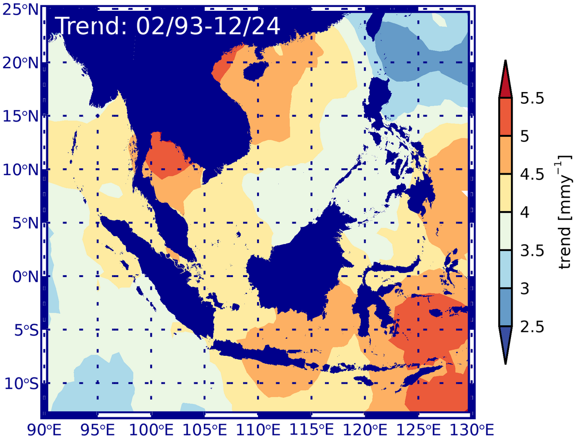
Both coastal subsidence and regional sea level rise (2024: 4.2mm/year off Jakarta) continue to have a significant impact on the living conditions of the population in coastal areas and are the focus of our active research.
Project partners:
- GITEWS & PROTECS (https://www.gitews.de)
- Badan Informasi Geospasial (Indonesia) (https://www.big.go.id)
- MARUM - Center for Marine Environmental Sciences, University of Bremen
- ZMT- Leibniz Center for Tropical Marine Research
Project duration:
- GITEWS: 2005 - 2011
- PROTECS: 2011-2014
- DFG Priority Program SPP 1889 (Regional Sea Level Change and Society) " Coastal and Regional Sea Level Changes and Subsidence - The Hazard Potential in Indonesia and Southeast Asia (CoRSEA)" (2016-2023) and “Holocene sea-level changes in Southeast Asia (SEASchange)” (2016-2019)
Financing:
- BMBF
- DFG
- Household/POF
Project related publications:
- Bott, L.-M., Illigner, J., Marfai, M., Schöne, T., & Braun, B. (2018). Meeresspiegelanstieg und Überschwemmung an der Nordküste Zentraljavas: Physische Ursachen und soziale Anpassungsmaßnahmen = Sea level rise and flooding on the north coast of central Java. Physical causes and social adaptation. Geographical Review, 70(4), 4-8.
- Mann, T., Schöne, T., Kench, P., Lambeck, K., Ashe, E., Kneer, D., Beetham, E., Illigner, J., Rovere, A., Marfai, M. A., & Westphal, H. (2023). Fossil Java Sea corals record Laurentide ice sheet disappearance. Geology, 51(7), 631-636. doi.org/10.1130/G51038.1
- Siriwardane-de Zoysa, R., Schöne, T., Herbeck, J., Illigner, J., Haghighi, M., Simarmata, H., Porio, E., Rovere, A., & Hornidge, A.-K. (2021). The 'wickedness' of governing land subsidence: Policy perspectives from urban Southeast Asia. Plos One, 16(6): e0250208. doi.org/10.1371/journal.pone.0250208
- Bott, L.-M., Schöne, T., Illigner, J., Haghshenas Haghighi, M., Gisevius, K., & Braun, B. (2021). Land subsidence in Jakarta and Semarang Bay - The relationship between physical processes, risk perception, and household adaptation. Ocean & Coastal Management, 211: 105775. doi.org/10.1016/j.ocecoaman.2021.105775.
- Mann, T., Rovere, A., Schöne, T., Klicpera, A., Stocchi, P., Lukmann, M., & Westphal, H. (2016). A revision of Holocene sea-level oscillations in the Strait of Makassar. Geomorphology, 257, 155-163. doi.org/10.1016/j.geomorph.2015.12.023
- Bender, M., Mann, T., Stocchi, P., Kneer, D., Schöne, T., Illigner, J., Jompa, J., and Rovere, A.: Late Holocene (0-6 ka) sea-level changes in the Makassar Strait, Indonesia, Clim. Past, 16, 1187-1205, doi.org/10.5194/cp-16-1187-2020, 2020
- Fenoglio-Marc, L., Schöne, T., Illigner, J., Becker, M., Manurung, P., & Khafid. (2012). Sea Level Change and Vertical Motion from Satellite Altimetry, Tide Gauges and GPS in the Indonesian Region. Marine Geodesy, 35(sup1), 137-150. doi.org/10.1080/01490419.2012.718682
- Schöne, T., Illigner, J., Manurung, P., Subarya, C., Khafid, Zech, C., & Galas, R. (2011). GPS-controlled tide gauges in Indonesia - a German contribution to Indonesia's Tsunami Early Warning System. Natural Hazards and Earth System Sciences (NHESS), 11(3), 731-740. doi:10.5194/nhess-11-731-2011
- Fenoglio-Marc, L., Schöne, T., Illigner, J., Becker, M., Manurung, P., & Khafid (2012). Sea Level Change and Vertical Motion from Satellite Altimetry, Tide Gauges and GPS in the Indonesian Region. Marine Geodesy, 35, Suppl. 1, 137-150. doi:10.1080/01490419.2012.718682
