Fracture-dominated development of a deep geothermal reservoir for electricity generation in the North-German Basin – Seismic exploration, concept and well planning at the Groß Schönebeck site – RissDom-A
Within the project phase RissDom-A, detailed seismic investigations of the geological structural elements of the magmatic and sedimentary target horizons, planning of a well with optimized design, and laboratory measurements of hydraulic properties of artificial fractures are carried out. Based on the results, decisions on the future development of the Geothermal Research Platform Groß Schönebeck in a follow-up project phase will be made. Currently, drilling of a new well and hydraulic stimulation treatments are seen as a possibility to investigate the sustainable utilization of the deep geothermal reservoir at this research site as an example for the North-German Basin (RissDom-B). Prior to this, the following questions are addressed in RissDom-A:
- Location of fault zones and other structural elements
- Characterization of the reservoir and hydraulic induced fracture systems under consideration of different stress conditions
- Choice of suitable completion materials for a geothermal well
Based on results of previous projects at the research site Groß Schönebeck, interpretation of existing data (drill cores, thermophysical fluid properties), and a new combined seismic survey, geological structural elements and their subsurface distribution are identified and characterized within RissDom-A. Besides a 3D surface seismic survey, which is carried out in cooperation with Section 2.7 Near-surface Geophysics, vertical seismic profiling (VSP) is performed in the existing boreholes using the innovative method of fiber-optic distributed acoustic sensing (DAS). The hydraulic properties of artificial fractures under variable stress conditions are investigated on samples from analogue material of the geothermal reservoir.
BMWi - German Federal Ministry for Economic Affairs and Energy
Grant no. 0324065
Duration: 01.06.2016 – 30.09.2018
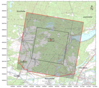
Seit 2002 führt das Deutsche GeoForschungsZentrum an der Geothermie-Forschungsplattform Groß Schönebeck exemplarisch Untersuchungen zur Nutzung tiefer geothermischer Ressourcen des Norddeutschen Beckens durch. In einem nächsten Schritt wurden vom 20. Februar 2017 bis zum 10. März 2017 im Umfeld der Geothermie-Forschungsplattform Groß Schönebeck 3D-seismische Messungen an der Oberfläche sowie in den am Standort existierenden zwei Forschungsbohrungen durchgeführt. Das Messgebiet schließt die Gemeinde Schorfheide sowie Randgebiete der Gemeinden Joachimsthal und Marienwerder ein. Zum Einsatz kam die Vibroseismik, das am wenigsten in die Natur eingreifende Erkundungsverfahren zur Untersuchung der Erdkruste. Ähnlich der medizinischen Ultraschalluntersuchung wird dabei der Untergrund von der Oberfläche her mit Wellen durchstrahlt, um die inneren Strukturen hochauflösend abzubilden. Die seismischen Messungen werden neue Erkenntnisse zur Lage und Struktur der Gesteinsschichten bis in eine Tiefe von ca. 4.000 Metern liefern. Eine erste Datenauswertung zeigt bereits, dass die Messkampagne ein Erfolg war. Die Daten versprechen ein detailliertes Abbild der tiefen geologischen Strukturen unter der Schorfheide. Mit dem Wissen können Rückschlüsse auf eine mögliche Nutzung tiefer Erdwärmeressourcen des Norddeutschen Beckens gezogen werden.


