


![[Translate to English:] Kartenausschnitt (Myanmar), der die Ruptur 1930, 1946, 1956 zeigt](/fileadmin/_processed_/2/9/csm_Map_view_of_rupture_propagation_history_of_the_28_March_2025_M7.7_2938732962.png "[Translate to English:]")
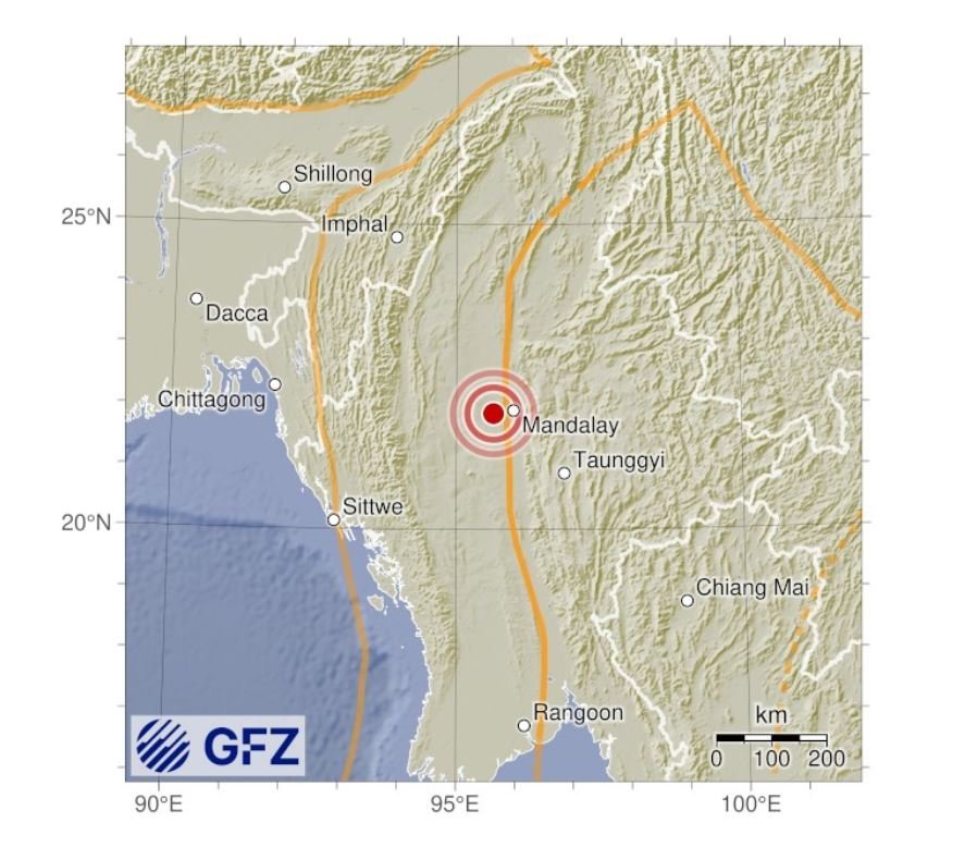
An earthquake with a magnitude of 7.7** (similar in size to the Turkish earthquake in February 2023) has occurred near the city of Mandalay, Myanmar. The GFZ experts assume a rupture length of more than 200 kilometers. The starting point (hypocenter) of the earthquake lies at a depth of around 24 km and for such large earthquake the rupture may have reached the surface.
The quake occurred on the so-called Sagaing Fault. This is a well-known fault where the Indian continental plate and the Eurasian plate meet.
At the Sagaing Fault, the Earth's plates move past each other at a rate of around 18 mm per year. The Sagaing Fault thus absorbs about half of the northward movement of the Indian plate.
Between 1930 and 1956, there were numerous earthquakes on the Sagaing Fault.
This was followed by a quieter phase in which great tension built up underground. This was now suddenly released by the strong quake. Further strong aftershocks are to be expected. An event of magnitude 6.4 already occured 12 minutes after the mainshock.
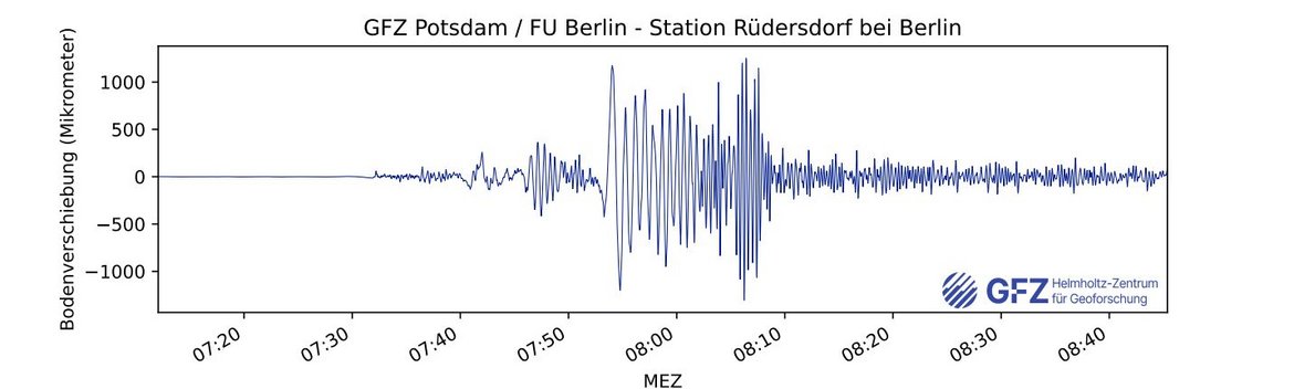
Such powerful earthquakes produce long-period seismic waves that can travel great distances. Tall high-rise buildings, which have long natural vibration periods, may sway and sustain damage when these waves reach them.
Status: 29.3.2025, 10:30 a.m.
(Status: 28.3.2025, 11 a.m. ; **Note: At the time the article was written, the moment magnitude was 7.75, rounded up to 7.8. After further scientific evaluation, a small correction was made to 7.72, then rounded down to 7.7. Further information on magnitude discrepancy (GEOFON FAQs) )
Further Information:
- All further GFZ information on earthquakes and live data can be found at: Current Earthquake Information
- Information of USGS about this event
- Please also note the information on this earthquake event of the Euro-Mediterranean Seismological Centre | Special Report Earthquake Event Myanmar
GFZ Project in Myanmar: “Collision-Subduction Transition in Myanmar-Yunnan | CoSuMY”
The GFZ GEOFON station network for recording earthquakes worldwide
UPDATE: 31.3.2025
Slowly, reports from the most affected regions in Myanmar are emerging and let us glimpse the scale of the destruction and the human toll, which currently stands at over 2000, but is expected to rise further as more remote locations are reached. We hope that the rescue efforts now under way are successful in rescuing further people.
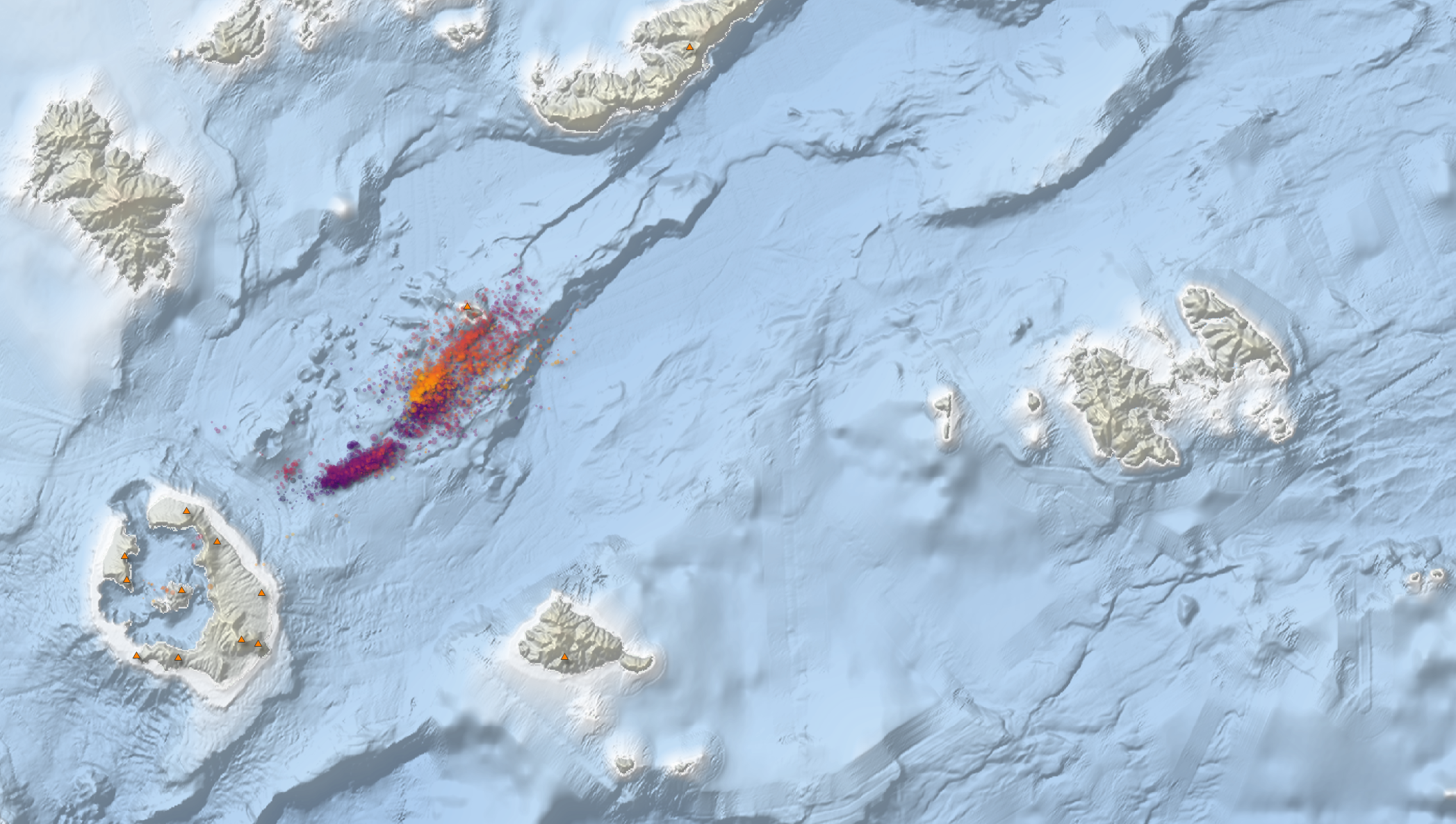
With an initial analysis, we now have obtained some preliminary insight into the rupture propagation process.
Or main findings: The rupture shows a distinct difference in propagation to the north and to the south with the southward rupture speed being nearly twice as high as the northward propagation rate. This highspeed bursting indicates a so-called supershear rupture. This is important as the seismic energy radiates strongly in the direction of the supershear rupture’s movement. This in turn would explain the heavy damage in more than 1,000 kilometres distance from the epicentre, e.g. the collapsed high-rise building in Bangkok.
+++ TECHNICAL REPORT +++
Specifically, we use the seismic stations in Europe, Japan, Alaska, and Australia as ‘seismic antennas’, so-called arrays (see the inset in the upper left part of our figure).
Using these arrays, we can track the detailed rupture history of the earthquake. Specifically, we track the emission of seismic energy at periods of 0.5 to 2 seconds, which tend to be the most relevant for buildings up to a few stories high (the tall buildings, which were most affected in Bangkok, are susceptible to slower oscillations at periods of a few seconds, but the energy emissions at those slightly longer periods are likely to be similar).
Starting at the epicentre near Sagaing and Mandalay, the rupture propagated both north and south with a rupture velocity of ~3 km/s, which corresponds to ~80% of shear wave velocity in the crust and thus represents a typical rupture velocity of most earthquakes (see the subfigure B in our figure). Whereas the northward propagating branch ends after about 30 s approximately 100 km north of the epicentre, the southward propagating branch continues for a total duration of 80 s and a length of over 330 km, resulting in a total rupture length of well over 400 km.
Highspeed rupture to the south
Remarkably, the southward propagating rupture accelerates up to a speed of ~5 km/s which is much faster than the shear wave speed, indicating a so-called supershear ruptures. A supershear rupture is the earthquake equivalent of a supersonic jet.
Supershear ruptures are rare for earthquakes in general but are fairly common for a special class of earthquakes. This special class are very large earthquakes (M>~7.5) along long simple strike-slip faults with little fault complexity, which allow for a smooth rupture progression. The Sagaing fault is just such a geometrically simple strike-slip fault.
The supershear rupture leads to a strong radiation of seismic energy in the forward direction. This so-called directivity effect might have exacerbated damage in Nay Pyi Taw (at 19.75°N) and played a role in explaining the unusually drastic effects experienced in Bangkok at over 1000 km distance to the epicentre, including the collapse of a high rise building under construction, but also damages at many other buildings (the other major factor is probably the presence of soft soil (marine clay) in the near surface and a thicker layer of sedimentary basin infill in Bangkok, which leads to resonance effects, as reported by other scientists).
Up to 6 metres of ground movement
We can understand some more details by putting our results in context by comparison with observations by other groups and the literature. The USGS (United States Geological Survey) published a so-called finite fault (FF) model, which describes the amount of slip incurred along the fault. The peak slip inferred in their model is > 6 m, corresponding to over 300 years of accumulated plate motion. Slip is significant (> 3m) along a fault length of approximately 300 km, marked by the yellow line in A.
Interestingly, the largest emission of high frequency seismic energy occurs one minute after the initial shock (see subfigures C and B at 60 s), which corresponds approximately to the southern end of the high slip region in the USGS FF model (transition between continuous and dashed yellow line in A). Note that the backprojection and FF slip model are seeing different aspects of the rupture. For a hypothetically perfectly smooth rupture along an idealised flat fault with uniform frictional properties, high frequency emissions would only be expected from the start and end of the rupture, known as starting and stopping phases.
We thus interpret the strong emissions at 60 s as a stopping phase indicating the end of the high slip phase of the rupture. Due to the strong deviations of actual faults from their idealised counterparts, clear stopping phases are rarely observed in nature. That they appear so clearly here is another piece of evidence supporting the smooth nature of the Sagaing fault, favouring supershear rupture. As can be seen in A, the high frequency emissions continue to the south of this cut-off point for nearly another 100 km, albeit less energetically than the stopping phase peak emission. The USGS model does in fact still show minor slip (just over 1 m) through most of this area, as indicated by the dashed line, so the FF and backprojection results are not in contradiction.
Historical earthquakes
The last earthquakes with magnitudes greater than 7 occurred in 1930, 1946 and 1956 along this fault, whose approximate latitudinal extent is shown with green lozenges in A (Hurukawa & Maung Maung, 2011).
The recent earthquake has clearly re-ruptured the rupture area of the 1956 earthquake (although it cannot be excluded that they occurred on parallel strands) and likely encroached on the rupture area of the 1946 earthquake. In contrast, the northern termination of the 1930 events seems to correspond more or less to the southern end of the 2025 rupture, with maybe some minor slip (as indicated by the last three emission points) embedded in it.
It is unclear why the southernmost edge of the rupture experienced only ~1 m of slip, and whether this is explained by the earthquake history prior to the 20th century, or whether this area (dashed line and darker red points in A) should be considered a heavily loaded seismic gap for a future M~7 earthquake, about 10 times smaller than the earthquake of March 28 but still posing a significant seismic hazard for structures nearby.
So, while the 2025 earthquake area was previously identified as a seismic gap (e.g. Hurukawa & Maung Maung, 2011), the actual rupture held some surprises, e.g. a much longer rupture length than expected, and the unexpected variation of slip magnitude within the gap area.
Disclaimer: All the results are preliminary and have not undergone peer review. Parts of the figure were assembled in inkscape, such that placement of literature results is only approximate. We continue the seismological analysis of this event and some refinement and revision of the interpretations expressed above is likely.
Sources:
USGS Finite Fault model: https://earthquake.usgs.gov/earthquakes/eventpage/us7000pn9s/finite-fault
Rupture areas of historic earthquakes: Hurukawa, N., & Maung Maung, P. (2011). Two seismic gaps on the Sagaing Fault, Myanmar, derived from relocation of historical earthquakes since 1918. Geophysical Research Letters, 38(1). https://doi.org/10.1029/2010gl046099


![[Translate to English:] Portrait Johann Komusiewicz](/fileadmin/_processed_/0/4/csm_Johann_Komusiewicz_schwarzer_Rahmen_ab0296c5cf.webp "[Translate to English:]")


![[Translate to English:] Abror Gafurov von dem Schriftzug "Welcome to Azerbaijan" und den UN und COP Logos](/fileadmin/_processed_/2/5/csm_2024_11_Baku_COP29_Abror_Gafurov_26a3f3a1b5.webp "[Translate to English:]")


