The term GNSS Reflectometry (GNSS-R) comprises various remote sensing techniques. GNSS-R exploits reflected navigation satellite signals from water, ice or land surfaces. Fundamental geophysical properties of the reflecting surfaces can be derived, as, e.g., altimetric heights, soil moisture or roughness, which can be, e.g., correlated with wind velocity and direction above water. The spectrum of applications is manifold and includes, e.g., weather forecast and climate research [1].
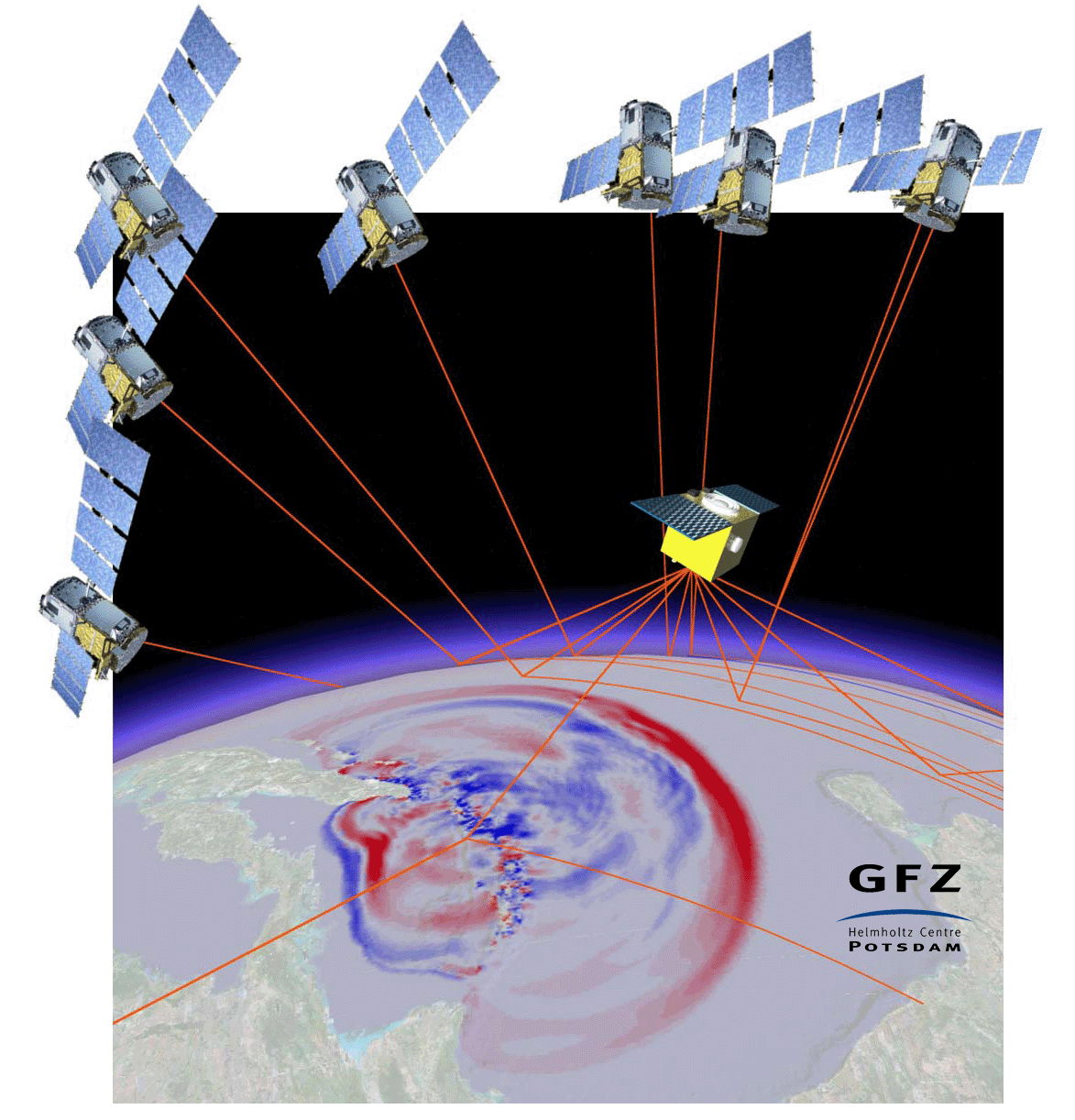
In the GFZ section Space Geodetic Techniques we work since more than 15 years on the development of the innovative GNSS-R remote sensing techniques. These activities were started with the detection of reflected signals in GPS radio occultation data, e.g., of the CHAMP satellite. Supported by the GITEWS project (German Indonesian Tsunami Early Warning System) these investigations were extended with first successful ground-based experiments and studies related to future satellite-based tsunami early warning systems [2]. In addition to the extension of ground-based measurements [3] and the analysis of reflectometry observations from flight platforms, as Airship, Aircraft and UAV, [4, 5] we focus at the moment on the satellite-based application for global Earth Observation. Examples for this are studies related to the application of GNSS-R aboard small satellites or at the International Space Station ISS within the GEROS-ISS [6] experiment of the European Space Agency ESA. Additional key activity was the G-TERN proposal [7] for a GNSS-R Mission within the Earth Explorer 9 programme of ESA. We are currently also involved in the ESA small satellite project PRETTY [8].
GFZ has been actively engaged in ocean and atmospheric monitoring using GNSS-R technology. This includes measuring surface wind speeds [9], developing methods for precipitation detection [10, 11], and leveraging artificial intelligence to achieve unprecedented accuracy in data retrieval [12]. In collaboration with partner institutes, GFZ has also expanded GNSS-R applications to detect vegetation water stress, providing insights into forest respond to droughts leading to mortality and wildfire [13].
Current Research
- AI4GNSSR | Artificial Intelligence for GNSS Reflectometry
- GNOSAR | GNSS-Reflectometry for Ocean Surface and Atmosphere Research
- Warm-Green | Water Stress Monitoring using GNSS Reflected Signals
- AMGr | Atmospheric model for GNSS reflectometry
- ArGID | Arctic GNSS Ice Detection
- GNSS-RSS | GNSS Remote Sensing aboard small satellites
References
[1] Wickert J., A. Egido, G. Elgered, S. Fuller, M. Gauss, R. Jongman, C. Martin-Puig, P. Monks, Novel GNSS applications for GEEO and GEOSS, Public Report of the GfG² project, European Union, FP7-ENV-2010 GA No. 265098, pp. 43, 2012.
[2] Stosius, R. Beyerle, G.; Hoechner, A.; Wickert, J.; Lauterjung, J., The impact on tsunami detection from space using GNSS-reflectometry when combining GPS with GLONASS and Galileo on GNSS-Reflectometry tsunami detection from space. Advances in Space Research, 47, 5, 843-853, https://doi.org/10.1016/j.asr.2010.09.022.
[3] Vey, S., Güntner, A., Wickert, J., Blume, T., Ramatschi, M.: Long-term soil moisture dynamics derived from GNSS interferometric reflectometry: a case study for Sutherland, South Africa. - GPS Solutions, 20, 4, p. 641-654, https://doi.org/10.1007/s10291-015-0474-0, 2016.
[4] Semmling, A. M.; Wickert, J.; Schön, S.; Stosius, R.; Gerber, T.; Markgraf, M.; Ge, M. & Beyerle, G. A zeppelin experiment to study airborne altimetry using specular Global Navigation Satellite System reflections, Radio Science, 2013, 48, 427–440, file:///C:/Users/wickert/Downloads/321321-1.pdf 2013.
[5] Semmling, A. M.; Beckheinrich, J.; Wickert, J.; Beyerle, G.; Schön, S.; Fabra, F.; Pflug, H.; He, K.; Schwabe, J. & Scheinert, M. Sea surface topography retrieved from GNSS reflectometry phase data of the GEOHALO flight mission Geophysical Research Letters, 2014, 41, 954-960, https://doi.org/10.1002/2013GL058725
[6] Wickert, J., Cardellach, E., Martin-Neira, M., Bandeiras, J., Bertino, L., Andersen, O. B., Camps, A., Catarino, N., Chapron, B., Fabra, F., et al.: GEROS-ISS: GNSS REflectometry, Radio Occultation, and Scatterometry Onboard the International Space Station, IEEE Journal of selected topics in applied earth observations and remote sensing, Vol. 9, Issue: 10, p. 4552-4581, doi.org/10.1109/JSTARS.2016.2614428
[7] Cardellach, E., Wickert, J., Baggen, R., Benito, J., Camps, A., Catarino, N., Chapron, B., Dielacher, A., Fabra, F., Flato, G., Fragner, H., Gabarró, C., Gommenginger, C., Haas, C., Healy, S., Hernandez-Pajares, M., Høeg, P., Jäggi, A., Kainulainen, J., Khan, S. A., Lemke, N. M., Li, W., Nghiem, S. V., Pierdicca, N., Portabella, M., Rautiainen, K., Rius, A., Sasgen, I., Semmling, M., Shum, C., Soulat, F., Steiner, A. K., Tailhades, S., Thomas, M., Vilaseca, R., Zuffada, C.: GNSS Transpolar Earth Reflectometry exploriNg system (G-TERN): Mission concept. - IEEE Access, 6, pp. 13980-14018, doi.org/10.1109/ACCESS.2018.2814072
[8] Cardellach, E., Li, W., Nahavandchi, H., Semmling, M., Moreno Bulla, M.A., Hoque, M. M., Wickert, J., Asgarimehr, M., Zus, F., Dielacher, A., Hoermanseder, W., and Moser-Moritsch, M. (2024) Precise GNSS-R Altimetry with the ESA PRETTY CubeSat: Initial In-Orbit Results. 2024 IEEE International Geoscience and Remote Sensing Symposium, Athens, Greece, https://2024.ieeeigarss.org/view_paper.php?PaperNum=4749
[9] Xiao, T., Arnold, C., Zhao, D., Mou, L., Wickert, J., Asgarimehr, M., 2024. Deep Learning in Spaceborne GNSS Reflectometry: Correcting Precipitation Effects on Wind Speed Products. IEEE J of Selected Topics in Appl. Earth Observations and Remote Sensing, 17, 17860-17875. doi.org/10.1109/JSTARS.2024.3453999
[10] Asgarimehr, M., Zavorotny, V., Wickert, J., and Reich, S. (2018). Can GNSS reflectometry detect precipitation over oceans?, Geophysical research letters, 45(22), 12-585. doi.org/10.1029/2018GL079708
[11] Asgarimehr, M., Hoseini, M., Semmling, M., Ramatschi, M., Camps, A., Nahavandchi, H., ... & Wickert, J. (2021). Remote sensing of precipitation using reflected GNSS signals: Response analysis of polarimetric observations. IEEE Transactions on Geoscience and Remote Sensing, 60, 1-12. doi.org/10.1109/TGRS.2021.3062492
[12] Asgarimehr, M., Arnold, C., Weigel, T., Ruf, C., & Wickert, J. (2022). GNSS reflectometry global ocean wind speed using deep learning: Development and assessment of CyGNSSnet. Remote Sensing of Environment, 269, 112801. doi.org/10.1016/j.rse.2021.112801
[13] Asgarimehr, M., Entekhabi, D., & Camps, A. (2024). Diurnal vegetation moisture cycle in the Amazon and response to water stress. Geophysical Research Letters, 51(19), e2024GL111462. doi.org/10.1029/2024GL111462