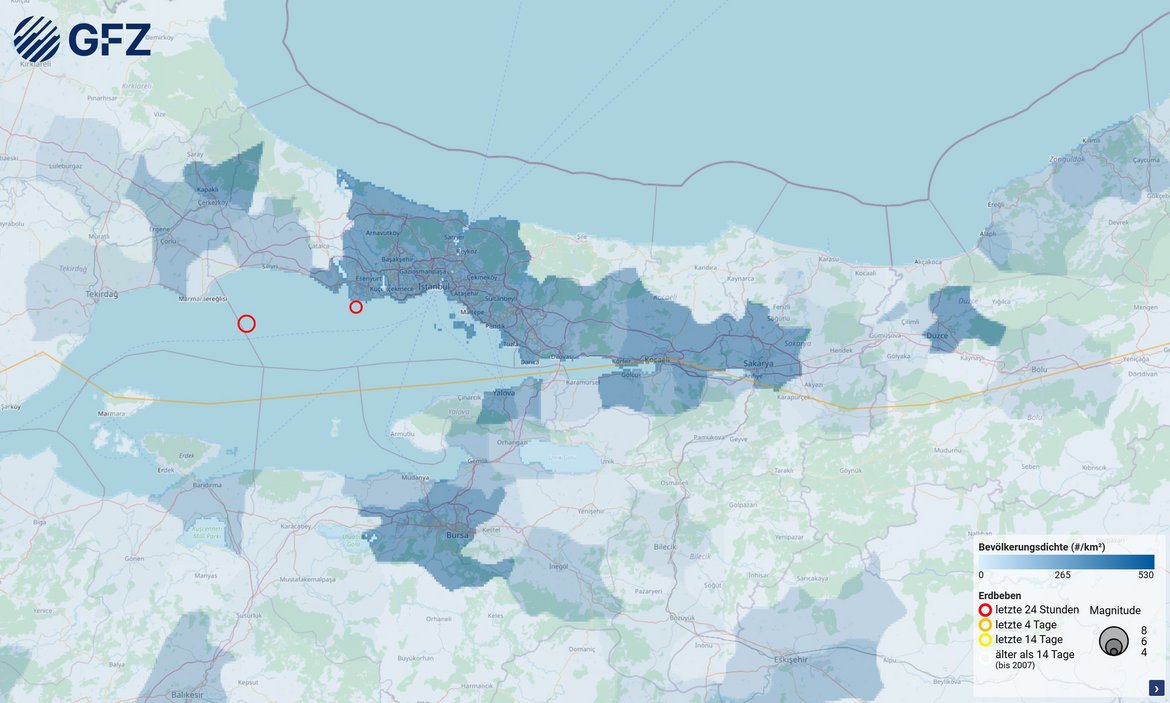


An earthquake with magnitude Mw 6.2, as measured by the GEOFON programme of the GFZ Helmholtz Centre for Geoscience, shook the city of Istanbul this morning, Wednesday, 23 April 2025. The epicentre of the quake, which struck at 11:49 CEST (12:59 local time), was located at a depth of approximately 10 kilometres, around 60 kilometres west of Istanbul in the Sea of Marmara. Just 13 minutes later, another quake measuring Mw 5.3 struck directly south of Istanbul, around 40 kilometres away.
“On 26 September 2019, a similarly strong earthquake measuring Mw 5.7 occurred at a similar location in the central Marmara Sea. Today's 6.2 earthquake extends the fault zone from that time, also in the direction of Istanbul. Overall, this fault line has enough energy stored to cause an earthquake with a magnitude of up to 7.4,” explains Marco Bohnhoff, head of the GFZ Geomechanics and Scientific Drilling section at the GFZ.
“We are monitoring the situation very closely. Today's earthquake is the most severe in the region in over 25 years. The focal mechanism, with a right-lateral offset, indicates that the earthquake occurred on the main fault. At this point in time, there are two scenarios: either the immediate region is now relaxed for the time being and the seismicity is slowly subsiding, or the stress redistribution caused by the earthquake increases the probability of a larger earthquake in the region. We are conducting further data analysis. The Turkish disaster control agency AFAD, our central cooperation partner in the GONAF project on site, is responsible for official forecasts.
The region around the Sea of Marmara near Istanbul, a megacity with more than 16 million inhabitants, has one of the most hazardous geological structures in the world. The North Anatolian Fault separates the Eurasian and Anatolian tectonic plates over a length of more than 1,000 kilometres from Eastern Anatolia along the Turkish Black Sea coast and through the Sea of Marmara to the northern Aegean Sea. Since the beginning of the 20th century, more than 20,000 people have died there in strong earthquakes with magnitudes greater than 7. The area below the Sea of Marmara south of Istanbul is the only area along the entire plate boundary that has not generated a strong earthquake for over 250 years and is therefore overdue for an earthquake with a magnitude of up to 7.4.
According to initial, still preliminary findings, the first earthquake today, with a magnitude of 6.2, occurred in the central part of the Sea of Marmara at the transition point between a slowly and ‘aseismic’ creeping part of the earthquake zone towards the west and the completely locked area to the east towards Istanbul. The fact that an earthquake measuring 5.3 occurred shortly afterwards south of Istanbul indicates that there have been stress redistributions that have increased the likelihood of further earthquakes in that area.
Further information: Geophysical Observatory on the Anatolian Fault – GONAF (www-gonaf-network.org)
The Anatolian microplate is a key region for investigations focusing on earthquake mechanisms, the interactions of seismicity at the plate level, and complex deformation processes at transform plate boundaries. At the northern edge of the Anatolian microplate, the North Anatolian Fault Zone (NAFZ) is one of the most important continental transform faults on Earth, forming a plate boundary more than 1,000 kilometres long with a significant earthquake hazard. Large parts of the Marmara Sea south of the megacity Istanbul form a so-called seismic gap along a fault segment more than 100 kilometres long. This means that there have been no severe earthquakes in this gap for a long time and that tension is therefore building up there. Using a high-resolution seismic borehole array around the eastern Marmara Sea (north-western Turkey), the work of the integrated plate boundary observatory is focusing on this fault segment. We hope to gain new insights into the physical processes that occur before and, if necessary, during and after a strong earthquake (M>7), as well as to redefine and calibrate earthquake models and carry out hazard assessments for the megacity of Istanbul in near real time. In this way, we are contributing to Istanbul’s early warning system.
Related publications:
Chen, X., Martínez‐Garzón, P., Kwiatek, G., Ben‐Zion, Y., Bohnhoff, M., Cotton, F., Rupture Directivity of Moderate Earthquakes Along the Main Marmara Fault Suggests Larger Ground Motion Towards Istanbul. Geophys. Res. Lett., 52, e2024GL111460.
https://doi.org/10.1029/2024GL111460, 2025
(> Press release)
Martínez-Garzón, P., Beroza, G.C., Bocchini, G. M., Bohnhoff, M., Sea level changes affect seismicity rates in a hydrothermal system near Istanbul. Geophys. Res. Lett., 50, e2022GL101258. https://doi.org/10.1029/2022GL101258, 2023.
(> Press release)
Becker, D., Martínez-Garzón, P., Wollin, C., Kılıç, T., Bohnhoff, M. Variation of fault creep along the overdue Istanbul-Marmara seismic gap in NW Türkiye. Geophys. Res. Lett., 50, e2022GL101471. https://doi.org/10.1029/2022GL101471, 2023.
(> Press release)
Malin, E.P., Bohnhoff, M., Blümle, F., Dresen, G., Martínez-Garzón, P., Nurlu, M., Ceken, U., Kadirioglu, F.T., Kartal, R.F., Kilic, T., Yanik, K., 2018. Microearthquakes preceding a M4.2 Earthquake Offshore Istanbul. Nature Scientific Reports. DOI: 10.1038/s41598-018-34563-9


![[Translate to English:] Portrait Johann Komusiewicz](/fileadmin/_processed_/0/4/csm_Johann_Komusiewicz_schwarzer_Rahmen_ab0296c5cf.webp "[Translate to English:]")


