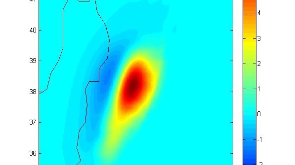
Earthquakes

  • source of the earthquake as a model
  • Diagram: The measurement at the relevant GEOFON station in Indonesia
  • The right figure shows the slip of the Eurasiean plate relative to the Pacific plate, inverted from the surface displacement data measured by more than 500 GPS stations, which are shown in the left figure.
  • Map of plate boundaries
  • Wave heights and isochrones of the Honshu Tsunami. Printable resolution (Image: Andrey Babeyko,

Earthquake Hazard in Turkey

  • Aerial view over western Istanbul and the Marmara Sea
  • Damaged house due to an earthquake
  • Destroyed buildings: damage caused by the Izmit earthquake
  • Earthquake hazard map of Turkey, epicentres and location of the main fault zones

Earthquakes in Chile

  • The map marks the wave heights in colour
  • The map shows a section of the Chilean coast with colour-coded magnitudes
  • The picture shows a rocky section of coastline that is partially no longer covered with water
  • The photo shows rocks in the sea
  • The figure shows the displacement vectors using red arrows
  • The photo shows a person working on the installation on the ground
  • Map Chile
  • Figure Earthquake mechanism at a subduction zone
  • The photo shows a dry mountain landscape with photovoltaic systems
  • The photo shows a fenced-in solar installation in a dusty landscape. There is a car behind the fence
  • Plate Boundary Observatory Chile
back to top of main content