High Altitude and LOng Range Research Aircraft | GEOHALO
The new German research aircraft HALO (High Altitude and LOng Range Research Aircraft) has been purchased by a joint initiative of the German Federal Ministry for Education and Research BMBF, the Max Planck Society, the Helmholtz Association, the state of Bavaria, the Reseach Centre Juelich, the Karlsruhe Institute for Technology KIT and the German Centre for Aeronautics and Space Research DLR. GFZ is partner of the HALO consortium. The German Research Foundation DFG is supporting projects on the HALO aircraft within the DFG High priority program SPP-1294 “Atmospheric and Earth System Research with the High Altitude and Long Range Research Aircraft (HALO)”.
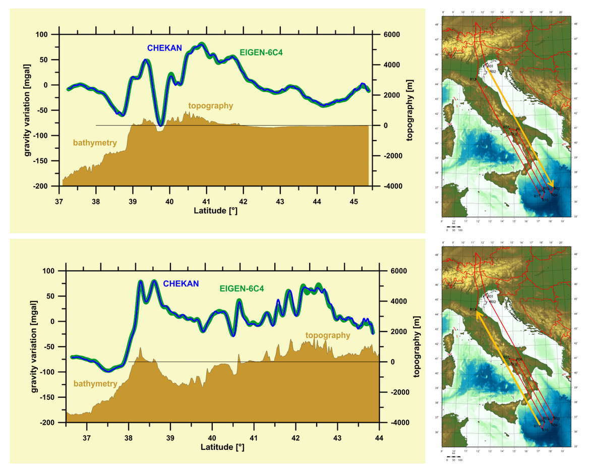
GEOHALO is the first scientific mission done on the HALO aircraft. It comprises an equipment of geophysical and geodetic sensors and has been conducted between June 4th and 12th 2013 in four flights over Italy.
GFZ was involved in the GEOHALO project with the topics "GNSS-Reflectometry", "Geomagnetic Field" and "Gravimetry". Our section was responsible for the Gravimetry. It was the intention to show whether and how an efficient airborne gravity field determination is feasible in wide areas when using a fast aircraft like HALO at higher altitudes. Here, unlike “classical” airborne gravimetry for exploration, the aim is not primarily the highest spatial resolution by flying as low and slow as possible. The task is to map areas where only insufficient or no terrestrial gravity data are available to achieve a resolution which is considerably better as that of satellite-only gravity field models. This is beneficial for the generation of global gravity field models which require a uniform, high spatial resolution for the gravity data over the entire Earth. Hence, future targets for HALO will mainly be areas with bad or sparse terrestrial data and regions which are inaccessibly for terrestrial gravimetry on ground.
The figures below show first comparisons between gravity variations deduced from the HALO measurements and the global gravity field model EIGEN-6C4 which contains satellite and terrestrial gravity data. To remove the high frequency noise of the Chekan measurements and of the GNSS derived vertical kinematic accelerations a low-pass filter with a cut-off wavelength of 200 seconds has been applied. With a flight speed of 425 km/h this results in a spatial resolution of 12 km half-wavelength. This corresponds to the resolution of the model EIGEN-6C4, which can be assumed as very accurate in this area due to the good and dense gravimetrical data included. It’s clearly visible, that HALO coincides very well with EIGEN-6C4.
Project Partners:
- GFZ, Sections 1.1 “Space Geodetic Techniques” and 2.3 “Geomagnetism“
- Federal Institute for Geosciences and Natural Resources (BGR), Hannover
- Eidgenössische Technische Hochschule (ETH), Zurich
- Institut de Ciències de l’Espai (ICE – CSIC/IEEC), Barcelona
- German Space Operations Center (DLR-GSOC), Oberpfaffenhofen
Project Duration:
- 2008 – 2012
Funding:
The GEOHALO project was co-funded by the German Research Foundation (DFG) from 2008 to 2011 with material and personnel resources (see also: https://gepris.dfg.de/gepris/projekt/47386703?language=en). This funding was provided as part of the priority programme SPP 1294 “Atmospheric and Earth System Research with HALO (High Altitude and Long Range Research Aircraft)”
Project related publications:
- Schaller, T., Scheinert, M., Barthelmes, F., Förste, C. (2019): Inversion of GEOHALO aerogravimetry to infer ocean bottom topography: application to the Tyrrhenian, Ionian and Adriatic seas. - Geophysical Journal International, 216, 2, 840-850.
https://doi.org/10.1093/gji/ggy456 - Lu, B., Barthelmes, F., Petrovic, S., Förste, C., Flechtner, F., Luo, Z., He, K., Li, M. (2017): Airborne Gravimetry of GEOHALO Mission: Data Processing and Gravity Field Modeling.Journal of Geophysical Research, 122, 12, 10,586-10,604.
https://doi.org/10.1002/2017JB01442